THE HISTORICITY OF NEW TESTAMENT GEOGRAPHY
Anonymous
(Investigator 183, 2018 November)
Anonymous
(Investigator 183, 2018 November)
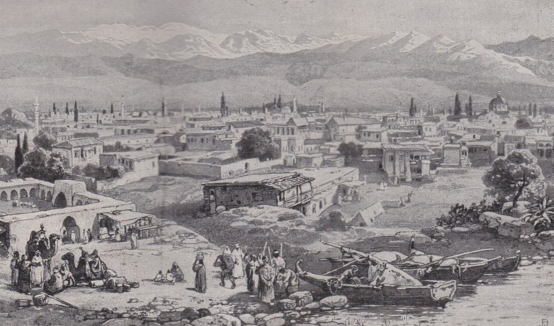
Tarsus. From: Schneller, D.L. 1926 Paul The Life of the Apostle
INTRODUCTION
The New Testament has many names of people, provinces, cities, towns,
islands and other locations — hundreds of names. Such detail created
great scope for the writers to make mistakes, undermining the claim
that "all scripture is inspired of God".
In this article we'll investigate the accuracy of the New Testament in geography. I will list named locations and occasionally add comment.
In this article we'll investigate the accuracy of the New Testament in geography. I will list named locations and occasionally add comment.
MAINLAND PROVINCES, TOWNS, and AREAS
In CE 68 the Roman Empire had 36 provinces of which 11 were public
provinces (governed by proconsuls selected by the senate) and 25 were
imperial provinces (with governors appointed by the emperor).
The New Testament mentions about 20 provinces by name:
PALESTINE:
A region composed of three provinces Galilee, Samaria and Judea, ruled in Paul's lifetime by the Herodian Dynasty.
[Note, regions are large areas, sometimes comprising several provinces, whereas districts are usually local areas.]
GALILEE:
One of three Roman provinces that constituted Palestine. It was part of the Kingdom of Herod the Great, 40-4 BCE; afterwards a part of the Tetrarchy of Herod Antipas, c.4 BCE – CE 39.
Towns/Villages/Areas:
• Bethsaida-Julias: 3km north of Lake Galilee
• Bethsaida: Hometown of Philip, Andrew & Peter (John 1:44), NW of Lake Galilee
• Cana
• Capernaum: At Capernaum under a fifth-century church excavators have found remains of
1st century houses, including possibly the house of Peter — Mark 1:21-30.
• Chorazin
• Dalmanutha
• Magdala
• Nain
• Nazareth: Village where Jesus grew up. Its existence was long denied until archaeologically
excavated. (See Investigator 19-22, 25, 131)
• Tiberias
• Gennesaret: An area in Galilee
SAMARIA:
One of three provinces that constituted Palestine in the 1st century:
Cities/Towns:
• Caesarea: seat of Roman Government
• Sychar: Village near Jacob's well
• City of Samaria: Capital of the province
• Caesarea: seat of Roman Government
• Sychar: Village near Jacob's well
• City of Samaria: Capital of the province
JUDEA:
One of three provinces that made up Palestine:
Cities/Towns/Places:
• Aenon: A place where John baptized
• Antipatris: NW of Jerusalem, identified with Tel Afek
• Arimathea: Hometown of Joseph who donated his tomb for Jesus.
Arimathea's location is commonly identified with Rantis, a Palestinian town 35km NW of
Jerusalem.
• Bethany
• Bethany across the Jordan
• Bethlehem: Jesus' birth location
• Emmaus: Village 10 km from Jerusalem
• Jericho
• Jerusalem: Capital of Judea and center of religion and culture
• Joppa: Seaport NW of Jerusalem
• Lydda: Village near Joppa
• Salim: Place where John baptized
SYRIA:
A province that included most of the Holy Land until 70 CE except parts ruled by various Herods
Towns/Cities/Regions:
• Antioch: Third largest city of the Roman Empire; capital of Syria
• Damascus: Prosperous Syrian city where Paul was converted
• Abilene: District north of Damascus
• Trachonitis: District south of Damascus
• Seleucia: Seaport near Antioch
• Phoenicia: Coastal area of Syria
• Sidon: A Phoenician city
• Tyre: Phoenician seaport
• Ptolemaeus [Acco]: Town south of Tyre
• Caesarea Philippi: City near Mount Hermon between Syria and Galilee; the most northern
part of Jesus' ministry
PHRYGIA:
A region composed of two provinces, Asia and Galatia
ASIA:
Province in Western Turkey
Towns/Cities:
• Cnidus
• Colossae
• Ephesus: Capital city
• Hieropolis
• Laodicea
• Miletus: Seaport 60km south of Ephesus
• Smyrna
• Thyatira
• Trogyllium
• Cnidus
• Colossae
• Ephesus: Capital city
• Hieropolis
• Laodicea
• Miletus: Seaport 60km south of Ephesus
• Smyrna
• Thyatira
• Trogyllium
GALATIA:
Province in central Asia Minor composed of three regions, Phrygia, Pisidia, Lycaonia
Towns/Cities:
• Antioch: City at the border of Phrygia and Pisidia
• Iconium: In Pisidia near the border with Lycaonia
• Derbe: Lycaonia
• Lystra: Lycaonia
• Antioch: City at the border of Phrygia and Pisidia
• Iconium: In Pisidia near the border with Lycaonia
• Derbe: Lycaonia
• Lystra: Lycaonia
CILICIA:
Province in SE Asia Minor
City:
• Tarsus: Chief city; home-city of Saul/Paul
• Tarsus: Chief city; home-city of Saul/Paul
LYCIA:
Small coastal province in SW Asia Minor
Towns/Cities:
• Myra: Port city
• Patara: Seaport
• Myra: Port city
• Patara: Seaport
BITHYNIA:
Province in NW Asia Minor
MYSIA:
Province in NW Asia Minor
Towns/Cities:
• Adramyttium
• Assos
• Pergamos: Chief city
• Troas: City with seaport
• Adramyttium
• Assos
• Pergamos: Chief city
• Troas: City with seaport
PAMPHYLIA:
Coastal Roman province of southern Asia Minor
Towns/Cities:
• Attalia: Port city
• Perga: Capital city
• Attalia: Port city
• Perga: Capital city
CAPPADOCIA:
Province in central Asia Minor
GREECE:
A country consisting of two Roman provinces, Achaia and Macedonia
ACHAIA:
Province of southern Greece
Cities:
• Athens
• Corinth
• Cenchrea (Port/harbor of Corinth)
• Athens
• Corinth
• Cenchrea (Port/harbor of Corinth)
MACEDONIA:
Province of northern Greece
Towns/Cities:
• Amphipolis
• Apollonia
• Beroea
• Philippi
• Neapolis, seaport of Philippi
• Thessalonica
• Amphipolis
• Apollonia
• Beroea
• Philippi
• Neapolis, seaport of Philippi
• Thessalonica
EGYPT:
Province in North Africa
City:
• Alexandria: Second largest city of the Roman Empire
ILLYRICUM:
Province on the east side of the Adriatic.
Dalmatia: Region comprising the southern half of Illyricum
ITALIA:
Province that included most of Italy
Towns/Cities:
• Rome: Capital of the Empire
• Puteoli: Seaport
• Rhegium: A port city on the Italian side of the Strait of Messina
• Rome: Capital of the Empire
• Puteoli: Seaport
• Rhegium: A port city on the Italian side of the Strait of Messina
CYRENAICA [LIBYA]
City:
• Cyrene
• Cyrene
SPAIN
REGIONS/DISTRICTS NOT LISTED ABOVE
ARABIA:
The region south and east of Palestine including Sinai Peninsula and Mount Sinai.
DECAPOLIS:
A league of ten semi-independent Greek cities SE of Galilee. Of these ten cities the Bible mentions only "country of the Gadarenes" (Gadara); and "country of the Gerasenes" (Gerasa).
PEREA:
Region east of the Jordan River and Dead Sea ruled by Herod Antipas. Perea is not mentioned in the New Testament but was the probable location of Gomorrah and Sodom (Jude 7).
IDUMEA:
Roman name for Edom, east and south of the Jordan River, homeland of Herod the Great
LYDIA:
Region on the west coast of Asia Minor
Towns/Cities:
• Sardis: Capital of Lydia
• Philadelphia
• Sardis: Capital of Lydia
• Philadelphia
PONTUS: Large district in Asia Minor along the Black Sea Coast
ISLANDS
Chios: An Aegean island off the west coast of Asia Minor
Cauda: Small island SW of Crete
Cos: Island between Miletus and Rhodes
Crete:
Large Mediterranean island south of Greece
Towns and places:
• Lasea: Seaport of Crete
• Fair Havens: Harbor near Lasea
• Phoenix: An ancient harbour of Crete, exact location uncertain due to possible changes in
the coastline
• Salmone: Cape Sidero, eastern Crete
• Lasea: Seaport of Crete
• Fair Havens: Harbor near Lasea
• Phoenix: An ancient harbour of Crete, exact location uncertain due to possible changes in
the coastline
• Salmone: Cape Sidero, eastern Crete
Cyprus:
An island in the Eastern Mediterranean. Cyprus in the 1st century was a
senatorial province meaning that the Roman senate appointed a proconsul
to administer it instead of a prefect as in Judea where Pontius Pilate
was prefect. Luke uses different Greek words for the two
positions — Cyprus had an "anthupatos" or proconsul. (Acts 13:7)
Towns:
• Paphos: Capital of Cyprus
• Salamis
• Paphos: Capital of Cyprus
• Salamis
Lesbos:
An island in the Aegean Sea
Town:
• Mitylene: Capital of Lesbos
Malta:
Island situated between Italy and North Africa
Patmos:
Small island in the Aegean Sea near Ephesus
Rhodes:
Island in the Aegean Sea
Samos:
Island in the Aegean Sea
Samothrace:
Island in the northern Aegean Sea
Sicily:
Sicily is not named in the Bible but its main city/seaport, Syracuse, is mentioned in Acts 28:12.
RIVERS, LAKES and SEAS
• Euphrates River
• Sea of Galilee [Lake Gennesaret]
• Jordan River
• Red Sea
• Sea of Adria: A part of the Mediterranean Sea east and north of Malta
• Syrtis: Shallow area with sandbars on African coast SE of Malta
COUNTRIES OUTSIDE OF THE 1st-CENTURY ROMAN EMPIRE
• Mesopotamia
• Media: A country east of Mesopotamia
• Parthia: A country between Media and India
• Elam: North of the Persian Gulf
• Babylon
• Ethiopia
LOCATIONS WITHIN OR NEAR CITIES/TOWNS
Jerusalem:
• Zion: Temple Mount area
• The Temple
• Solomon's Porch
• Court of the Gentiles
• Beautiful Gate
• Gehenna/Hell [= Valley of Hinnom]
• Gethsemane Garden
• Akeldama: a Field purchased with Judas' 30 pieces of silver
• Golgotha/Calvary/The Skull: Site of Jesus' crucifixion, exact spot still disputed
• House of Caiaphas
• Kidron Valley
• Mount of Olives
• Pool of Bethesda
• Pool of Siloam
• Praetorium: Headquarters/palace of Pilate
• Sheep Gate
• Tower of Siloam
Athens:
- Areaopagus [Mars Hill]: A rocky elevation opposite the west end of the Acropolis
- Straight Street
- Lecture Hall of Tyrannus
- Appius Way: Road from Puteoli to Rome
- Appius Market
- Three Inns (Shops): Stopping place 60km south of Rome
PAUL'S VOYAGE to ITALY
Paul's sea journey to Italy met with a great storm:
When the fourteenth night [of the storm] had come, as we were drifting
across the sea
of Adria, about midnight the sailors suspected that they were nearing land.
They took soundings and found twenty fathoms [120 feet]; a little further on they took
soundings again and found fifteen fathoms [90 feet]. (Acts 15:27-28)
In the morning … they noticed a bay with a beach, on which they planned to run the
ship ashore, if they could. (Acts 15:39)
But striking a reef they ran the ship aground; the bow stuck and remained immovable… (Acts 15:41)
The term "Adria" or "Adriatic" (Acts 27:27) does not refer to the
Adriatic Sea. A NIV Bible footnote says: "In ancient times the name
referred to an area extending well south of Italy." Egyptian geographer
Ptolemy (90-168) distinguished the Gulf of Adria which is today's
Adriatic Sea from the Sea of Adria lying between Crete, Malta, Italy
and Sicily.
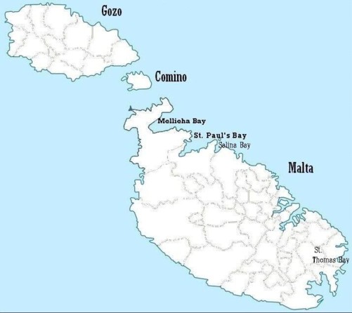
The country of Malta consists of three main islands named Gozo, Comino and Malta. (Map 1) Paul's shipwreck traditionally occurred in Saint Paul's Bay at the NE of the main island.
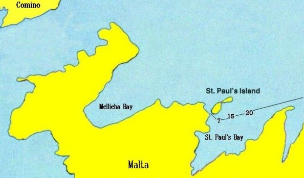
Map 2 shows the likely course of the ship and the depths of 20 and 15
fathoms where soundings from Paul's ship were taken, and 7 fathoms
where the anchors may have been cast off. (Acts 27:40) The depths can
be confirmed on Malta Marine Chart MT_2538_0 available on the Internet.
The suspected spot of the wreck is the 100-metre-wide channel between
the main island and tiny Saint Paul's Island (also called Selmunett).
In 1576 another ship went aground exactly where Paul's ship supposedly did:
However, whichever Maltese bay gets final confirmation doesn't effect whether the biblical narrative is true.
19th century Bible scholars believed Acts was written around CE 200, or 150 years after the events and geography it depicts, and is hopelessly wrong.
Ramsay discovered:
The Bible's accuracy in geography and other testable statements supports the claim:
REFERENCES:
All the Names of the Bible 2014, Thomas Nelson, USA
Douglas, J.D. et al (editors) 1982 New Bible Dictionary, Second Edition, Inter-Varsity, p. 1030
Fairchild, M.R. Why Perga? Biblical Archaeology Review, November/December 2013, 52-59, 84
Frank, H.T. 1984 Atlas of Bible Lands, Hammond
Just, Felix, An Overview of New Testament Geography
http://catholic-resources.org/Bible/NT_Geography.htm
Ramsay, W.M. 1895 St. Paul the Traveller and the Roman Citizen, Hodder & Stoughton
Ramsay, W.M. 1915 The Bearing of Recent Discovery On The Trustworthiness of the New Testament, Hodder & Stoughton, 37-42, 89
Wahlde, U.C. von, The Puzzling Pool of Bethesda, Biblical Archaeology Review, September/October, 2011, 40-47
Malta Marine Chart: MT_2538_0
http://www.gpsnauticalcharts.com/main/mt_2538_0-malta-nautical-chart.html
Saint Paul's Island
https://en.wikipedia.org/wiki/St_Paul'_Island.htm
Shipwreck-location suggestions:
http://melitensiawth.nl/index/Proceedings of History Week (PHW)/PHW 1993/10s.pdf
http://www.baseinstitute.org/pages/pauls_shipwreck/20.htm
http://www1.cbn.com/cbnnews/world/2010/february/searching-for-pauls-shipwreck-on-malta.htm
https://chalcedon.edu/resources/articles/anchors-from-apostle-pauls-shipwreck-presumed-found.htm
https://exploring-malta.com/the-mistery-of-apostle-pauls-shipwreck-revealed-by-mark-gatt/.htm
https://www.um.edu.mt/think/the-mystery-of-st-pauls-shipwreck/.htm
1
2
The 100-metre wide channel is commonly interpreted as the "place where
two seas met" — King James Bible Acts 27:41. Other Bibles speak of a
"reef" or "shoals" instead of "two seas".
In 1576 another ship went aground exactly where Paul's ship supposedly did:
In 1576, Marco di Maria was being chased by Barbary corsairs off the
coast of Malta. He navigated his vessel through the narrow channel
between St Paul's Island and Malta, but when the pirates followed him
they ran aground and were captured. (Wikipedia)
Current World Archaeology reports that four anchors discovered in the
sea near Malta in the 1960s "were recently dated to the 1st century
AD". (April/May 2013, p. 57) The exact location is not given but
various web pages claim four anchors were discovered in the 1960s near
the entrance of Saint Thomas Bay, SE Malta. Another anchor was found at
sea between Saint Paul's Bay and Salina Bay.
However, whichever Maltese bay gets final confirmation doesn't effect whether the biblical narrative is true.
Three months later Paul continued his journey on another ship. This
ship weighed anchor at Rhegium on the east side of Messina Strait which
separates Italy and Sicily. Here they waited one day until "a south
wind sprang up". (28:13) The Bible does not explain the importance of
waiting for a south wind but the New Bible Dictionary explains:
With the whirlpool of Charybdis and the rock of Scylla endangering
navigation through
the Strait, it was important to attempt the passage only with the most favourable sailing
wind, and shipping moving N would wait at Rhegium for a S wind.
the Strait, it was important to attempt the passage only with the most favourable sailing
wind, and shipping moving N would wait at Rhegium for a S wind.
FACTS of ACTS
19th century Bible scholars believed Acts was written around CE 200, or 150 years after the events and geography it depicts, and is hopelessly wrong.
Smith's Bible Dictionary originally published in 1863, agrees with
Roman authorities such as Cicero in regarding Iconium as the capital of
Lycaonia. The book of Acts in contrast implies Lycaonia was across the
border from Iconium and had a different language. (14:1-11)
William Mitchell Ramsay (1851-1939) was a Scottish archaeologist and New Testament scholar who worked extensively in Asia Minor.
In The Bearing of Recent Discovery On The Trustworthiness of the New Testament (1915) Ramsay describes his initial scepticism:
William Mitchell Ramsay (1851-1939) was a Scottish archaeologist and New Testament scholar who worked extensively in Asia Minor.
In The Bearing of Recent Discovery On The Trustworthiness of the New Testament (1915) Ramsay describes his initial scepticism:
I
had read a good deal of modern criticism about the book, and
dutifully accepted the current opinion that it was written during the
second half of the second century by an author who wished to influence
the minds of people in his own time by a highly wrought and imaginative
description of the early Church. His object was not to present a
trustworthy picture of facts in the period about A.D. 50, but to
produce a certain effect on his own time by setting forth a carefully
coloured account of events and persons of that older period. He wrote
for his contemporaries, not for truth. He cared nought for geographical
or historical surroundings of the period A.D. 30 to 60. He thought only
of the period A.D. 160-180...
Such was the commonly accepted view in the critical school about 1870 to 1880, when I had been studying modern opinions...
I began then to study the Acts in search of geographical and antiquarian evidence, hardly expecting to find any... (pp 37-39)
The first thing that made me begin to doubt ... the late origin of "the Acts of the Apostles" was a discovery regarding the geographical statement in XIV. 5: "They fled (from Iconium) to the cities of Lycaonia and the surrounding region". In these words it is implied that Paul and Barnabas fled over a frontier into Lycaonia, i.e. the border of Lycaonia lay between Iconium and Lystra, and Iconium was not in the country called Lycaonia...
Around 400 B.C. the Greek writer Xenophon had described Iconium as the
last city of Phrygia. The author of Acts failed to consider that
borders change in 400 years and naively accepted this — so argued
critics who relied on Cicero. Ramsay writes,
Cicero, who visited Iconium ... speaks of Iconium as being in Lycaonia almost exactly a century before Paul visited it...
...the writer of the book [Acts] was condemned as an impostor... Here in Acts XIV. 5, we have a test case: at this point it seemed to me, when I began this study of Anatolian geography, that the story had been proved to ring false. The author of the book imparts a piece of topographical information incidentally ... but the information is false and results from his applying a piece of schoolboy knowledge, true in regard of 400 B.C., to the different circumstances of A.D. 47...
...the writer of the book [Acts] was condemned as an impostor... Here in Acts XIV. 5, we have a test case: at this point it seemed to me, when I began this study of Anatolian geography, that the story had been proved to ring false. The author of the book imparts a piece of topographical information incidentally ... but the information is false and results from his applying a piece of schoolboy knowledge, true in regard of 400 B.C., to the different circumstances of A.D. 47...
Ramsay discovered:
Iconium was not in Lycaonia at that period. It belonged to a different
region or district of Asia Minor. Its people were of a different stock,
and they did not speak the Lycaonian tongue... (p. 42)
You may press the words of Luke in a degree far beyond any other historian's, and they stand the keenest scrutiny... (p. 89)
You may press the words of Luke in a degree far beyond any other historian's, and they stand the keenest scrutiny... (p. 89)
In 1910 inscriptions in the Phrygian language were discovered at
Iconium and proved that the Phrygian language was in use there until
the third century.
CONCLUSION
The New Testament's accuracy in geography is close to 100%.
Geographical statements still unconfirmed are not necessarily errors
but unconfirmed due to inconclusive evidence.
The Bible's accuracy in geography and other testable statements supports the claim:
For we did not follow cleverly devised myths when we made known to you
the power
and coming of our Lord Jesus Christ, but we had been eyewitnesses of his majesty.
(II Peter 1:16)
and coming of our Lord Jesus Christ, but we had been eyewitnesses of his majesty.
(II Peter 1:16)
Therefore anyone who already believes "all scripture is inspired of
God" and investigates New Testament geography can rationally retain his
belief since he has tested it and found it unrefuted. Someone else who
has hitherto regarded the Bible as bunkum obviously needs to reconsider.
REFERENCES:
All the Names of the Bible 2014, Thomas Nelson, USA
Douglas, J.D. et al (editors) 1982 New Bible Dictionary, Second Edition, Inter-Varsity, p. 1030
Fairchild, M.R. Why Perga? Biblical Archaeology Review, November/December 2013, 52-59, 84
Frank, H.T. 1984 Atlas of Bible Lands, Hammond
Just, Felix, An Overview of New Testament Geography
http://catholic-resources.org/Bible/NT_Geography.htm
Ramsay, W.M. 1895 St. Paul the Traveller and the Roman Citizen, Hodder & Stoughton
Ramsay, W.M. 1915 The Bearing of Recent Discovery On The Trustworthiness of the New Testament, Hodder & Stoughton, 37-42, 89
Wahlde, U.C. von, The Puzzling Pool of Bethesda, Biblical Archaeology Review, September/October, 2011, 40-47
Malta Marine Chart: MT_2538_0
http://www.gpsnauticalcharts.com/main/mt_2538_0-malta-nautical-chart.html
Saint Paul's Island
https://en.wikipedia.org/wiki/St_Paul'_Island.htm
Shipwreck-location suggestions:
http://melitensiawth.nl/index/Proceedings of History Week (PHW)/PHW 1993/10s.pdf
http://www.baseinstitute.org/pages/pauls_shipwreck/20.htm
http://www1.cbn.com/cbnnews/world/2010/february/searching-for-pauls-shipwreck-on-malta.htm
https://chalcedon.edu/resources/articles/anchors-from-apostle-pauls-shipwreck-presumed-found.htm
https://exploring-malta.com/the-mistery-of-apostle-pauls-shipwreck-revealed-by-mark-gatt/.htm
https://www.um.edu.mt/think/the-mystery-of-st-pauls-shipwreck/.htm
The accuracy of the Bible is tested on this website since 2001 CE
and in Investigator Magazine since 1988:
and in Investigator Magazine since 1988: